
Geographic Location of Fish River Canyon
The Country and Continent
For anyone asking where is fish river canyon, the answer begins with the African continent. The canyon sits in Namibia, on the Atlantic side of Africa, about 130 kilometers west of the town of Karasburg and less than 70 kilometers from the South African border.
Namibia is a country of desert and open sky, wedged between South Africa, Botswana, and Angola. The canyon lies within the Karas Region and forms the heart of the Ai-Ais Richtersveld Transfrontier Park, a protected area that stretches across the Orange River into South Africa’s Northern Cape Province.
This places the canyon at a truly southern latitude, comparable to Cape Town’s placement on the map. To reach it, travel south through Namibia on the C10 road and you will arrive at the rim. The location itself is arid, remote, and still, yet it is remarkably accessible from two countries at once.
GPS Coordinates and Map Placement
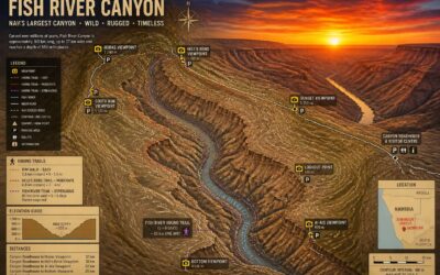
At 160 kilometers long and up to 550 meters deep, the Fish River Canyon ranks among the world’s largest gorges. The GPS coordinates, 27°18′ S and 17°35′ E, place you at Hobas, the main viewpoint on the eastern rim. If you ask where is fish river canyon, follow the C10 road south from Keetmanshoop. The canyon runs southwest, curving toward the Orange River and the Ai-Ais hot springs.
Use these markers to orient yourself on a map:
- Hobas viewpoint, 27°25′ S, 17°40′ E
- Ai-Ais Resort, 27°55′ S, 17°30′ E
- Sendelingsdrift border post, where the park crosses into South Africa
The coordinates sit at the same latitude as Vanrhynsdorp in the Western Cape. That position ensures winter frost and summer heat, an interior climate isolated from the Atlantic fog at Lüderitz. Where is fish river canyon on a map? It lies at Namibia’s southern tip, a remote stretch of terrain reachable from both sides of the Orange River.
Distance from Major Namibian Cities
The Fish River Canyon sits roughly 600 kilometers south of Windhoek, a drive that introduces you to Namibia’s gravel roads and their opinions about your suspension. You aren’t heading toward a town. You’re heading toward a geological tantrum that carved itself into the earth. Most travelers break the trip at Keetmanshoop, the nearest settlement with anything resembling a decent fuel station.
Consider these distances before you commit:
– Keetmanshoop: 140 kilometers north, the last practical supply point.
– Lüderitz: 400 kilometers west, though the coastal fog won’t assist you.
– Mariental: 500 kilometers northeast, a town you’ll pass if coming from the capital.
So where is fish river canyon in driving terms? It’s a full day from Windhoek, a half day from Keetmanshoop, and a world away from anything urban. The route down the C10 passes open plains, then the canyon simply appears. No neon sign. Just a vast gash in the ground. Pack water, snacks, and a healthy respect for empty roads. The remoteness is the entire point.
The Canyon’s Position in the Local River System
Where is fish river canyon positioned within the region’s hydrology? It forms the lower drainage channel of the Fish River, a temporary watercourse that runs roughly 650 kilometers from its source near the Namibian highlands. The canyon terminates where this river joins the Gariep River, also known as the Orange River, at the border with South Africa.
That joining point shapes everything. The Fish River carries sediment only during sporadic floods, which explains the canyon’s steep walls and flat floor. The local system includes no major perennial branches. The main features are:
- The Fish River itself, flowing southward
- Small dry tributaries that feed it during storms
- The Gariep River at the canyon’s exit
So the canyon exists because of this arrangement. The river’s seasonal rage cuts into ancient rock, and the Gariep carries the debris onward. The position of the canyon within this system explains its shape and isolation.
Regional Context and Surrounding Landscape
The Southern Namibian Terrain
The southern Namibian terrain does not so much roll as it cracks. Around the gorge, the earth presents a sun-blasted face of ancient schist and granite, broken by the occasional quiver tree. This is Nama Karoo country, where annual rainfall is a modest figure and the horizon extends without interruption.
The immediate landscape flanking the canyon presents three distinct features:
- Rocky escarpments dropping sharply into sandy riverbeds
- Dwarf shrubs and pale grasses scattered across gravel plains
- Thermal springs pooling in the Ai-Ais valley below the rim
If you are asking where is fish river canyon, the terrain itself provides the answer. It sits cradled in this vast, unforgiving wilderness, a geological scar cut over millennia, with the Fish River threading the only persistent moisture across a parched landscape.
Proximity to the Orange River and South African Border
The southern flank of Fish River Canyon presses close to the Orange River, a mere 30 kilometres from the canyon rim. That river marks Namibia’s boundary with South Africa, making the gorge a short detour from the Northern Cape. I have watched travellers cross at the Sendelingsdrift border post, then face the canyon’s fractured landscape within an hour.
This proximity shapes the terrain in concrete ways. The Orange River’s ancient floodwaters carved the canyon’s lower reaches, and the same schist and granite continue southward into South Africa.
- The Ai-Ais hot springs emerge from deep faults linked to the same rifting that formed the canyon.
- Road access from the border uses the C10 and C12, both gravel yet regularly graded.
- The neighbouring Richtersveld range mirrors the Fish River’s rugged gorges across the river.
So where is fish river canyon in regional terms? It sits at a shared boundary, a geological fracture that politics inherited.
Nearby Towns and Settlement Areas
The surrounding landscape is severe and open, a territory of dry riverbeds and sun-blasted plains. The nearest settlements to the canyon are sparse but distinct. Ai-Ais holds a hot spring resort at the canyon’s southern end. Aus, roughly 130 kilometres northwest, is known for its wild desert horses. Bethanie, a historical mission town, rests further inland. Where is fish river canyon in this distributed community? It runs directly through the middle of this quiet country, connecting these outposts by gravel roads that most maps still show as faint lines. The settlements survive on livestock and tourism, and their distance from any major city gives the entire region a genuine isolation.
The Wider Karas Region
The wider Karas Region demands attention. It is Namibia’s southernmost administrative area, where ancient metamorphic rock meets the edge of the Kalahari sands. The landscape is defined by dry channels rather than flowing rivers, and by granite inselbergs rising abruptly from gravel plains.
To understand where is fish river canyon, one must accept a country of long distances and short water. The Karas Mountains cut a diagonal line across the west, while eastern plains stretch into shrubland and scattered quiver trees. The region also holds some of the southern Namib’s most severe dune fields.
Several factors shape the region’s character:
- Annual rainfall below 200 millimetres, most of it in brief summer storms.
- A reliance on underground aquifers for livestock and permanent communities.
- Geological formations over a billion years old, among the oldest exposed surfaces on Earth.
I have learned that patience is required here, and the rewards come slowly. The canyon exists as a singular incision into this immense and ancient ground.
Connection to the Ai-Ais National Park
To answer where is fish river canyon with any degree of finality, you must consider its protective shell. The canyon sits within the Ai-Ais National Park, a vast tract of wilderness that spans the harsh southern frontier. This park is not merely a boundary drawn on a map; it is the reason the canyon retains its raw, untamed character. The landscape here forms a stark transition zone, where the rugged canyon walls give way to the flat, arid plains that stretch toward the Orange River.
The connection between the canyon and the park is symbiotic, with the park acting as a buffer against the encroaching desert. One can traverse the park’s gravel roads and witness the dramatic shift in flora and fauna. The terrain becomes increasingly lunar as you approach the canyon’s edge, a prelude to the geological drama below. For those pondering where is fish river canyon, the answer is found in this sudden, breathtaking rupture in the earth.
Within the park’s boundaries, specific features define the experience:
1. The Ai-Ais hot springs, a thermal oasis near the canyon’s southern end.
2. The Fish River Hiking Trail, a demanding multi-day route that follows the canyon floor.
3. The park’s role in protecting the region’s unique desert-adapted wildlife, including the Hartmann’s mountain zebra.
The park’s management ensures the canyon’s ecosystem remains pristine, a stark contrast to the more developed areas to the south. The proximity to the South African border adds a layer of remote significance, making the journey feel like an expedition into a forgotten world. This is the true context for where is fish river canyon rests, a sanctuary carved by ancient water in a land of eternal sun.
Getting to Fish River Canyon from Key Gateways
Driving from Windhoek
Driving from Windhoek to the Fish River Canyon requires more than a full tank of fuel. The route follows the B1 south to Mariental, then Keetmanshoop, where you turn onto the C12 and finally the C27, a gravel track that demands your attention. Most travellers plan a full day, with one overnight stop at the Canyon Roadhouse.
Fill up in Keetmanshoop; the next fuel comes at the canyon. Watch for wildlife.
To grasp where is fish river canyon, you need to sit behind the wheel for this final leg. The gravel road stretches over 100 kilometres, passing through the Huns Mountains before the rim appears. Key checkpoints:
- The Seeheim turnoff, 40 minutes from Keetmanshoop
- The C12/C27 junction, a signpost in the dust
- The park entrance gates, 10 kilometres past the lodge
Allow extra time for punctures and photo stops. This drive clarifies where is fish river canyon better than any map.
Approaching from Cape Town via the Border
Approaching from Cape Town, the border crossing at Vioolsdrif changes everything. One moment you are on familiar Northern Cape tar, the next you are past immigration and into a landscape that feels older than maps. From the border post, the canyon lies roughly 450 kilometres north, but do not let the distance fool you. The route pulls you through Noordoewer, then onto the C10, a quiet road that tracks the Orange River before bending inland. Along the way, the paving gives way to well-graded gravel. You will know you are close when the Huns Mountains rise like a wall of fire. For those asking where is fish river canyon in practical terms, it is exactly one border, one long gravel stretch, and one last climb beyond the park gate. Pack spare fuel and water. The border town has fuel, but the canyon region does not. This crossing from South Africa is often quieter than the Namibian routes, which means solitude, but also zero room for error. Check your spare tyre before leaving Vioolsdrif. The road will test your patience before it rewards you with the rim.
The Hobas Viewpoint Entrance
The Hobas Viewpoint Entrance answers where is fish river canyon more directly than any map. It is the eastern door, reached from the C12 after turning off the B4 near Keetmanshoop. The final kilometres are gravel, corrugated in places, and the landscape flattens before dropping away without warning.
I always tell first timers to slow down at that last rise. The entrance fee hut appears first, then the rim reveals itself, a sudden absence of ground. From Hobas, the main viewpoint is a short walk, and the canyon opens like a wound in the earth. This gateway suits those who want the iconic panorama without the long descent.
The Ai-Ais Resort Entrance
The Ai-Ais Resort Entrance answers where is fish river canyon from the southern end. This gateway sits closest to the South African border, reached by crossing at Noordoewer and following the tarred road along the Fish River. The canyon here offers no dramatic viewpoint. It narrows as the road pushes toward the resort.
I have watched travellers arrive at Ai-Ais expecting the Hobas panorama. Instead they find the hot springs and the trailhead where the Fish River hiking route concludes. The entrance fee is paid at the resort gate.
- The road from Noordoewer to Ai-Ais is fully tarred, a point in its favour for hire cars.
- The resort’s thermal spring feeds a swimming pool.
So where is fish river canyon for the driver coming from South Africa? It is at the end of that tarred road. You do not view it from above here. You stand in it.
Road Conditions and Vehicle Requirements
A standard sedan will reach Hobas and Ai-Ais without drama, but the gravel connectors around the canyon punish low clearance. Drivers crossing from South Africa should treat the C12 with respect. It is graded, yet corrugation appears without warning.
For a smoother experience, a bakkie with high clearance is the sensible choice. Fuel is available at Grünau and Keetmanshoop, not at the canyon itself.
- Spare tyre and jack are non-negotiable
- Check the tread before leaving the tar
- Keep a full cooler and water in the cabin
The question where is fish river canyon often ignores how the road treats you. The answer is easiest reached with patience and a vehicle that can handle stone chips.
Private Tours and Self-Drive Options
Keetmanshoop feels like the natural gateway, but the real choice happens on the C12. That gravel road splits attention between the view of distant mountains and the need to dodge stones. Where is fish river canyon becomes answerable through planning. Private tours remove the guesswork. They depart from Lüderitz or Windhoek with a guide who knows the canyon and the border posts.
- Private tours include transport, permits, and guide fees
- Self-drive requires park entry paid at the gate
Self-drive travellers trade that assurance for freedom. Starting from Grünau, the Ai-Ais gate is a short run! From Hobas, the viewpoints stretch south. Both approaches link through the park’s internal roads. That distinction matters more than mileage. The canyon’s entrance is a destination, but getting there builds the story.
Geographical Features and Scale of the Canyon
Length, Depth, and Width Measurements
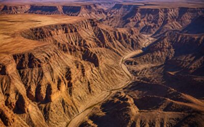
Understanding where is fish river canyon begins with its sheer dimensions. This rugged gorge stretches roughly 160 kilometres from start to finish. At its deepest point, it plunges around 550 metres. The widest sections open up to 27 kilometres across. These numbers become tangible only when you stand at the rim, as I have, and watch shadows move across the rock walls below.
The scale impresses. The canyon’s breadth shifts dramatically, narrowing to a sliver at the riverbed, then widening into open basins. Each bend reveals a different character, a quiet marker of millions of years of erosion by the river itself. Such scale places it among the largest canyons on the continent, a fact that often surprises first-time visitors.
The Course of the Fish River
If you have ever wondered where is fish river canyon in terms of its anatomy, think of it as a serpentine scar carved by a stubborn river. The Fish River does not rush. It meanders, bends, and occasionally throws a tantrum through the rock.
The canyon’s geography alternates between sheer vertical cliffs and sloping terraces, with the river snaking along the bottom. The course itself is a sequence of dramatic turns, where ancient granite and sandstone expose layers like pages of a geological diary.
- The river’s course creates sharp horseshoe bends
- Dry waterfalls mark old river levels
- The surrounding plains drop sharply into the gorge
Each meander forces the water against the opposing wall, undercutting the rock and widening the gorge over millennia. From the rim, you see the river as a thin silver thread, but its path explains the canyon’s unusual curves. That is the real answer to where is fish river canyon: nowhere straight, and always winding.
Surrounding Ecosystems and Wildlife
The rim stretches without warning. One step over the edge and the ground vanishes. The canyon’s geographical features are a brutal choreography: vertical sandstone walls, ancient granite terraces, and talus slopes that collapse at a touch. This scale is not visible from space photographs. Standing on the lip, the opposite rim sits almost two kilometers away in places. The depth surpasses 500 meters, and the temperature difference between top and bottom can reach 20 degrees Celsius.
That thermal gap shapes the ecosystems. The top supports scattered acacia and hardy grasses. The inner gorge harbors wild tobacco, quiver trees, and a persistent river. Wildlife follows the vertical gradient. Some species stick to specific bands:
- Rim: ostrich, oryx, and black-backed jackal
- Upper slopes: mountain zebra and chacma baboon
- Riverbed: clawless otter and African bullfrog
Where is fish river canyon in all this? It is a species refuge. The isolation of the gorge means animals below never interact with those on the rim. A single descent changes the biological context entirely.
Geological History and Formation
Some call the Fish River Canyon a simple gorge. The scale tells a different story. It is a geological scar, a wound carved over hundreds of millions of years by the persistent flow of water and the brutal collapse of stone. The canyon sits within a larger trough, a depression that predates the river itself. This basin formed roughly 500 million years ago during the Gondwana breakup, when the earth’s crust stretched and fractured. The river is a relative newcomer, having only begun its work of cutting into this ancient landscape around 50 million years ago.
The walls are not one solid mass. They are a layered fortification of time.
– The top layer is a cap of dark, dolerite rock that resists erosion.
– Below this sits a thick band of yellowish sandstone and quartzite.
– The deeper strata reveal ancient gneiss and granite, some of the oldest rocks on the continent.
These geological layers dictate the shape of the canyon. The harder rock forms sheer cliffs, while the softer layers erode into sloping terraces. This process is still ongoing. The canyon widens each year, not by the river’s force, but by the silent, inevitable collapse of the canyon walls. Understanding the terrain answers the question of where is fish river canyon in a more profound way than any map. It is a place defined by its own violent past, where the earth is still settling into its final form.
Climate and Seasonal Access at the Canyon’s Location
Summer Temperatures and Heat Risks
Summer temperatures routinely exceed 40°C from November to February, with a diurnal swing that offers little relief even after sundown. The heat presents genuine risks. Dehydration and heatstroke account for the majority of reported incidents in this part of southern Namibia, which is why park authorities close the main hiking trail once the mercury rises past 38°C. For those asking where is fish river canyon, the summer months expose a severe reality.
Seasonal access follows a strict logic. The cooler months between May and September provide the only safe window for descending into the gorge, and even then, hikers must set off before dawn. Consider the practical consequences of this climate:
- Water sources along the route shrink dramatically by November
- Rescue response times stretch due to impassable heat
- Road surfaces soften, affecting vehicle traction
That last point surprises many visitors, yet it matters.
Winter Conditions and Mild Days
Winter transforms this landscape into a more forgiving environment. Daytime temperatures hover around a pleasant 20°C, a stark contrast to the furnace of summer. Nights, however, can drop below freezing, so anyone camping needs proper gear. The dry air keeps the sky clear, offering uninterrupted views of the gorge. People asking where is fish river canyon often expect desert heat, but the winter climate tells a different story. The hiking trail opens fully during these months because the risk drops considerably. Yet the cold demands preparation just as much as the heat does.
Consider what this means for planning:
– Pack layers that handle both warm afternoons and icy mornings
– Expect no rain between May and September
– Book accommodation early, as winter is the peak visiting period
Moderate temperatures make this the only sensible time to explore the canyon on foot, and the calm conditions reward those who make the effort.
Rainfall Patterns and Trail Closures
Rain defines access here more than temperature does. Most precipitation arrives as short, violent thundershowers between January and April, often localised and intense. These storms can flood the narrow gorge floor in hours, transforming the riverbed from a dry dust path into a raging torrent. The water disappears as quickly as it arrives, but the aftermath matters for anyone asking where is fish river canyon.
Trail closures follow this pattern directly. The full hiking trail shuts each year from March through mid-August, not just because of the heat, but because flash floods make the route genuinely dangerous. Sections become impassable, and rescue becomes nearly impossible.
The dry months from June to September bring no closure risk at all. The sky stays clear, the riverbeds turn to cracked earth, and the path sits open for the entire season. Rain simply does not exist on the calendar during winter, which is why every serious hiker bookmarks this window the moment they learn where is fish river canyon.
Best Months to Visit Based on Location
Daytime temperatures in the canyon’s winter season rarely exceed 25 degrees Celsius, yet nights often plunge below freezing. That variation defines the experience for visitors who arrive between June and August.
For travelers asking where is fish river canyon, the answer shifts with the calendar. The driest months offer stable access to the inner gorge, while January’s thundershowers can close pathways without warning. July stands out as the most reliable month for extended expeditions.
Where is fish river canyon most welcoming? The winter half of the year. The best months to visit based on location are those that avoid both the scorching summer and the brief but fierce rains. Winter delivers clear skies, firm trails, and uninterrupted views of the ancient rock walls.
Nearby Points of Interest and Visitor Facilities
Ai-Ais Hot Springs and Resort
Ai-Ais Hot Springs and Resort marks the southern end of the canyon, a useful reference for anyone asking where is fish river canyon in practical terms. The thermal water arrives at 60 degrees Celsius, then cools in a series of open-air pools. In my experience, late afternoon heat feels purposeful, and the surrounding rock turns amber.
Facilities here include bungalows, a campsite, and a restaurant. The reception desk issues hiking permits, and a petrol station prevents unnecessary detours. Birdwatchers often spot fish eagles along the riverbank in winter.
- Curio shop
- Picnic areas under acacia trees
- Shaded parking
The resort also lies close to the Sendelingsdrift border post, which eases access for South African visitors. It serves as a complete base, eliminating the need to carry extra supplies.
Hobas Campsite and Viewpoints
Hobas Campsite sits at the canyon’s middle section, roughly 20 kilometres south of the main viewpoint gate. The site itself is basic by design. Shaded stands, braai facilities, and a small kiosk cover most needs. For anyone asking where is fish river canyon in relation to Hobas, this is the point where the hiking trail begins its descent.
The viewpoints above the canyon offer different angles at sunrise and late afternoon. Some overlook sharp river bends; others frame flat-topped ridges to the east. The short walk from the car park leads to the most practical lookout:
- A direct sightline to the canyon floor
- A clear view of the trail’s switchbacks
- Open ground for photography without obstructions
The Fish River Canyon Hiking Trail
The hiking trail that descends from Hobas does more than connect two points. It becomes a slow study of patience. For anyone still asking where is fish river canyon, the first two hours of walking provide the clearest reply: a narrow footpath that follows the river’s buried meanders, where the only sound is your own breath.
Visitor facilities along this route are deliberately absent. No kiosks, no shaded benches. Instead, the trail offers emergency markers at each overnight stop. These flat stone cairns serve a single purpose, to remind you that help is far away. The real infrastructure is the canyon itself, its sheer walls holding the heat of the day long after sunset.
- The trail’s overnight zones are named for their physical features, not for comfort.
- Each zone provides a windscreen of stacked rock, nothing more.
- Water points exist only at the trailhead and at Ai-Ais, making every litre a personal cargo.
This minimalism changes how you see the canyon. You stop observing from a viewpoint and start negotiating with the terrain.
Border Towns and Cultural Stops
A five minute drive from the Ai-Ais gate, the border town of Noordoewer sits on the Orange River. It has a filling station, a few guesthouses, and a busy border post. For travelers asking where is fish river canyon, this crossing sets the southern boundary.
- Grunau, a railway junction with fuel and a hotel
- Karasburg, the largest town in the area, with banks and shops
- Bethanie, 200 kilometres northwest, home to a mission church from 1859
The Nama people have lived here for centuries. Their cultural stops include graveyards, water wells, and community meeting grounds that predate the border. These sites receive few visitors, yet they hold the region’s history.
Connecting Routes to the Richtersveld
For travelers who keep asking where is fish river canyon, the southern exit leads to a peculiar neighbor. The Richtersveld lies across the Orange River, and the route goes through Noordoewer then trails southwest to Sendelingsdrift. A hand-hauled pontoon ferries vehicles over the water; it operates during daylight and charges a small fee. Visitor facilities cluster at the river’s edge, some more polished than others.
- Basic fuel and cold drinks at the Sendelingsdrift shop
- Permits for the Richtersveld National Park issued on the spot
- A shady picnic spot with a view of the canyon’s far wall
For any self-driver, this crossing is the practical link between two wild landscapes. Knowing the canyon also means knowing how to leave it.
0 Comments