
Planning Your Fish River Canyon Trek
Valley Entry Points and Starting Locations
The fish river canyon route begins with a decision many hikers overlook: where exactly to step off the rim. Unlike a circular wander, this trek is a one-way descent into the gorge, ending roughly 90 kilometres later at Ai-Ais. Getting the starting location right shapes your entire first day.
Most parties park at the Hobas camp and take the marked path towards the viewpoint. From there, the infamous descent, a steep switchback scramble, drops you into the canyon floor. A few seasoned walkers arrange a drop-off further south, but the official route has a fixed starting gate.
Preparing for your first day involves a few practical checks:
– Confirm your shuttle back to Hobas from Ai-Ais.
– Carry enough water for the initial descent.
– Understand the permit office hours at the park entrance.
These details matter more than boot brand or backpack weight.
Recommended Itinerary Durations and Daily Distances
A five day traverse of the fish river canyon route demands a strange arithmetic. The distance is fixed at roughly 90 kilometres, yet the time it demands never stays the same. Most groups allocate four to five nights, and daily distances shift depending on where the water pools sit that particular year.
A workable pace breaks the canyon into sections:
- Day one, the descent and 10 kilometres of valley floor.
- Days two and three, 15 to 18 kilometres daily through the narrowing gorge.
- Day four, a longer push to reach the hot springs pools.
- Day five, a short walk to Ai-Ais.
Add a reserve day when packs are heavy or October heat has been cruel. Afternoon sun on the fish river canyon route punishes impatience, so a dawn start is not a suggestion. It is the only sane way to respect the distances.
Packing List and Essential Gear for the Desert Climate
The fish river canyon route punishes the unprepared. Every kilogram in your pack adds weight to each step. Carry too much and you will suffer. Carry too little and the heat will find you.
Water is the first priority. The route offers no reliable sources outside the river itself, and those pools often sit far from the trail. Take my word for it, a four litre capacity is the baseline. Seasoned hikers carry five or six litres when October heat presses down.
- Broad brimmed hat with a chin strap
- Lightweight long sleeve shirts
- Leather gloves for rock scrambles
- One litre water bottles, tested before departure
Footwear deserves deep thought on the fish river canyon route. The canyon floor shifts between sand, loose scree, and slick bedrock. Trail shoes dry quickly but lack ankle support. Boots protect ankles but hold water for days. Most veterans choose a sturdy approach shoe with grippy soles.
Navigating the Terrain, Conditions and Physical Demands
Understanding the Steep Descent into the Canyon
The first plunge into the canyon reveals the true character of the fish river canyon route. Your legs absorb the impact of every downward step, and loose scree underfoot demands constant attention. This descent requires a measured approach, a steady balance between momentum and control. I have watched hikers charge down this slope and struggle an hour later.
Conditions shift as you lose elevation. The air thickens, heat radiates from the rock walls, and the gradient taxes your quadriceps in ways flat walking never will. The physical demands here are deceptive. You expend significant energy moving downward, and the cost returns later when the trail turns upward.
- Steep switchbacks require deliberate foot placement
- Loose gravel increases the risk of slips
- Morning shade offers relief, but the midday sun exposes the full slope
The fish river canyon route forces a slow, measured pace, and the climb out demands a different kind of strength.
River Crossings, Water Levels and Flow Dynamics
The canyon floor is a sprawl of fractured stone and shifting sand. The river slides through, carrying sediment that hides an uneven bed of slick boulders and sudden holes. I have watched hikers pause at the water’s edge, gauging the current with an anxiety that never quite fades.
Water levels on the fish river canyon route turn on rainfall far upstream. A crossing that barely wets your boots in the morning can rise to the waist by afternoon. The current pushes harder than it appears, and the cold water shocks the breath from your chest.
- Early morning crossings meet the lowest flow of the day
- Slick boulders lie just beneath the discoloured surface
- Rainfall upstream turns gentle channels into swift runs
Flow dynamics reshape the canyon floor day by day. Gravel bars appear and vanish. The river demands slow, deliberate negotiation, foot by foot. The fish river canyon route gives no warnings, only the silent pressure of moving water against your legs.
Campsites, Water Points and Strategic Rest Stops
Most people underestimate the physical demand of the fish river canyon route. The trail is not a walk in the park. It is a relentless sequence of climbs over loose rock and descents into sandy washes. Your knees take a beating on the downhills, and your calves burn on the uphill slogs. The terrain constantly changes underfoot, demanding your full attention with every single step. You will find yourself using muscles you forgot you had, and the heat amplifies every effort.
The canyon offers little shade, so the sun becomes a constant companion. You will sweat more than you thought possible. The dry air hides the fluid loss until it is too late. Fatigue builds over consecutive days, not just hours. The distances between rest points are deliberate, but they are not forgiving. A steady, measured pace beats any sprint. The route rewards those who conserve their energy for the long haul.
Campsites along the fish river canyon route are basic, rugged, and strategically placed. They are not luxury lodges. They are patches of flat ground near the water, often under the shade of ana trees or wild figs. Water points are the lifeblood of the trek. You must filter or treat everything you drink, and you learn to respect the value of a clean fill. The following rest stops are the busiest on the trail:
– The grassy banks at Palm Springs, which offer a welcome reprieve and soft ground
– The rocky outcrops at Arid Corner, which provide late afternoon shade
The positions of these stops matter. They break the long days into manageable chunks. Arriving early gives you the pick of the best spots and the time to properly filter water for the next stretch. The pace of the fish river canyon route is dictated by the sun, the river, and your own resilience. It is a raw experience, stripped of comfort, but every step is worth the effort.
Heat Management and Daily Hiking Pace Recommendations
Navigating the canyon floor demands a different gait than the approach. Loose scree sits above bedrock in places, and each footfall requires a deliberate placement. My own rhythm settled into a slow, steady cadence that preserved energy through the midday heat. The physical demands of the fish river canyon route become apparent within the first hour, especially when you face the unrelenting sun.
Heat management is a discipline. I found myself drinking before thirst, a habit that kept my mind clear and my legs moving. The dry air strips moisture quickly; the body warns you late.
Pacing on the fish river canyon route follows a simple rule: start early, rest in the shade by noon, and move again in the late afternoon. A typical day might look like this:
- Depart at first light while the rock is cool
- Stop for a long break between 11:00 and 15:00
- Resume as the shadows lengthen
This pattern protects your joints and your judgement.
Safety, Permits and Environmental Responsibility
Physical Fitness Standards and Training Preparation
The fish river canyon route does not ask for permission twice. It asks for proof of planning. Permits are strictly limited, and the regional authorities enforce quotas to protect the fragile desert ecosystem. Carry your permit slip, and leave every trace of your passage behind, including your waste, as the canyon floor is a living system. Physical fitness is the true currency here. I have seen strong hikers underestimate the daily cumulative strain. You should be comfortable hiking 20 kilometres with a 15 kilogram pack in 35 degree heat. Training must replicate those conditions, because gym sessions alone will not suffice. Build a baseline with these drills:
- Complete a 15 kilometre walk with a loaded pack weekly.
- Practice early morning starts to mimic hiking hours.
- Strengthen your ankles on rocky descents.
Environmental responsibility extends beyond permits. Water sources are scarce, so filter responsibly and carry salt tablets to avoid hyponatremia. The fish river canyon route rewards those who respect its limits!
Weather Hazards, Flash Floods and Emergency Protocols
When the first raindrops hit the canyon rim, you may have only minutes to react. The fish river canyon route channels runoff from distant storms into narrow gorges, creating flash floods that arrive with no warning. Weather hazards shift fast, so checking local forecasts daily and listening for thunder upstream becomes essential.
Permits and environmental responsibility tie directly into safety. Rangers use permit records to locate overdue hikers, so staying on your registered path is essential. Carry a whistle and know evacuation points. Emergency protocols require climbing at least 10 metres above the waterline when the river rises suddenly.
- Move away from tributary mouths.
- Leave a pack behind when it hinders ascent.
- Wait for the water to drop before attempting rescue.
Official Route Closures and Restricted Seasonal Access
Every fish river canyon route permit carries a hidden clause: the reserve can close the trail with little notice. Officials restrict access during flash flood season and after rockfalls, so confirm status with the Ai-Ais Richtersveld Transfrontier Park before driving to the trailhead.
Environmental responsibility starts with legality. Your permit ties your identity to the route, allowing rangers to track overdue hikers. Carry it laminated. Follow official route closures even if the path looks clear; a blocked section often signals unstable geology or wildlife presence.
- Check the park noticeboard for seasonal updates.
- Never enter restricted zones to photograph or camp.
- Report any damaged trail markers to the nearest ranger.
Restricted seasonal access typically runs from December to February. Rangers will issue no new permits during that window. Respect the closure. The fish river canyon route remains wild long after your journey ends.
Leave No Trace Principles and Waste Disposal Guidelines
Leave no trace is not a slogan on the fish river canyon route; it is the only system that works. The canyon has no waste collection points, no recycling stations, and no ranger to tidy up after careless hikers. Everything packed in must leave with you.
- Carry a leak-proof bag for organic and inorganic waste alike.
- Bury human waste at least 15 centimetres deep, 30 metres from water.
- Pack out all toilet paper and sanitary products in sealed bags.
Washing directly in streams or pools is a quiet act of destruction. Use a pot to haul water and wash well away from the channel. Even biodegradable soap disrupts fragile pools. A clean camp keeps scavengers away, and that is a safety matter as much as an environmental one. Permit holders carry the quiet duty of keeping the route intact for those who follow. The fish river canyon route survives only through this shared discipline.
Emergency Contact Systems and Evacuation Procedures
A single satellite call can separate a minor mishap from a full rescue operation. The fish river canyon route sits far from reliable cellular towers, so emergency communication depends on your own preparation. Permits are not paperwork, they are your lifeline. Each permit links you to the park’s emergency contact system.
Rangers monitor checkpoints and expect regular updates. If you fail to report, rescue protocols activate automatically. Know the evacuation routes before you descend.
- Carry a satellite communicator with preloaded emergency numbers.
- Memorise the three helipad locations along the trail.
- Share your daily plan with a trusted contact outside the canyon.
Environmental responsibility in an emergency means minimising rescue impact. Stay on marked trails when evacuating. The fish river canyon route rewards calm, deliberate decisions.
Guided Tours versus Independent Hiking Options
Booking a guided tour on the fish river canyon route transfers many safety burdens, from permit checks to daily status calls. Independent hikers carry those same duties alone, which rewards preparation but punishes oversight. Both options require knowing the helipads and evacuation paths; guides simply provide prior knowledge.
Environmental responsibility stays uniform for every party. You pack out all waste, and you stay on marked terrain. Guided groups often consolidate cooking and washing into shared systems, whereas independent hikers must replicate that efficiency from scratch. The fish river canyon route tests your commitment to leave no trace, regardless of who walks beside you.
- Verify your guide holds current park accreditation
- Confirm independent permits still mandate checkpoint reporting
- Ask about group waste handling before you book
Scenic Highlights, Wildlife and Cultural Landmarks Along the Trail
Iconic Viewpoints and Panoramic Overlooks to Prioritize
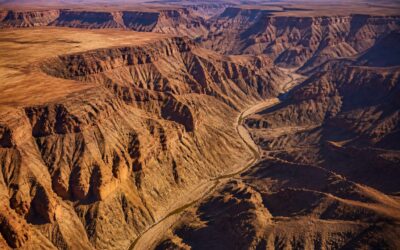
The fish river canyon route exposes 550 million years of geological strata across southern Namibia, a landscape that shifts from ochre to charcoal as clouds roll over the rim. Scenic highlights include the basin near Lot’s Wife, a volcanic dyke that pierces the canyon floor, and the folded quartzite bands visible along the eastern cliffs.
Wildlife sightings centre on klippspringer, baboons, and leopard tracks pressed into the dry river sand. Cultural landmarks appear in the stone circles and Nama herder cairns scattered across the upper terraces, remnants of generations who moved with these seasons. These quiet markers stand apart from the modern trail signs, offering their own chronology.
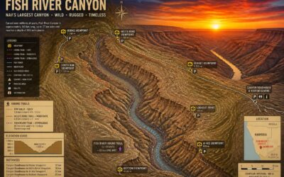
For panoramic overlooks, prioritise the Otto’s Peak viewpoints and the rim near Crystalline Hill. Hikers regularly rate these as the finest vantage points on the fish river canyon route!
Desert Wildlife Encounters and Plant Life Identification
On the fish river canyon route, I learned to spot life where none seems to exist. The quiver tree’s golden bloom contrasts with the dark volcanic rocks, while the Nara melon’s tangled vines stretch across sandy washes. A clan of rock hyraxes whistles from a boulder pile, and the tracks of an aardwolf trace the dawn shadows. Among the cultural remains, San rock art hides in a few shaded recesses, its ochre figures eroded by time.
- Euphorbia damarana: a toxic succulent that defends the rocky slopes.
- Camel thorn acacia: anchors the riparian zones with deep roots.
- Lichen crusts: paint the granite in silver and grey after rare fog.
Each step on this trail brings a new encounter, a small observation of endurance.
Photography Tips for Capturing the Canyon’s Depth and Light
Light is the true sculptor of this landscape. From the canyon rim, morning shadows fill the gorge, while late afternoon turns the quartzite cliffs deep ochre and rust. The fish river canyon route offers new compositions each hour, and the best shots require no tripod at all.
I found the most compelling photographs came from including scale. A lone hiker on a switchback, or a quiver tree against a rock face, gives the vastness meaning. Photograph across the gorge when the sun is low, and keep a polarising filter handy to cut the heat haze.
- Shoot east in the morning to catch warm light on the western walls.
- Shoot west in the afternoon for textured shadows on the eastern cliffs.
- Keep your camera ready for black eagles and klipspringers near the water points.
Cultural traces appear in the stone. Cairns mark the old herder trails, and a few shaded overhangs shelter faded San rock paintings. Photograph these with respect, using available light and no flash.
The Hot Springs and Geological Formations Worth Pausing For
Along the fish river canyon route, the hot springs near the eastern bank hold a constant 40 degrees. Mineral water seeps from the same fault that split this gorge. Hikers soak tired feet while black eagles ride thermals overhead. The contrast between cold river flow and warm spring water is striking.
The geology shifts every few kilometres. White quartzite bands mark ancient lava flows. Fossilised stromatolites appear in the dolomite cliffs, evidence of a prehistoric sea. Cairns and grinding stones from Khoisan herders rest beside the trail.
- The Palm Springs, a reliable water point year round.
- Sulphur vents bubbling through the river gravel.
- Basalt columns exposed at the fifth bend.
Klipspringers balance on sheer faces while baboons bark from shaded ledges. These formations and landmarks give every day on the fish river canyon route its own character.
0 Comments